Under the nationalist motto of "integrating to not deliver," the dictatorship transformed the Amazon forever.
It tore through the forest with thousands of kilometers of road, built hydroelectric power plants, and promoted colonizing agricultural projects.
In the process, it caused the death of thousands of indigenous people and paved the way for the illegal and disorderly deforestation that continues today.
It was the time of the "Brazil Power." The regime was in a hurry to advance on what it called the green desert. In 1970, the National Integration Program (PIN) was launched and it constructed highways and colonization projects.
The Transamazônica highway (BR-230) was at the center of the project. Amid a severe drought in the Northeast, military geopolitics had found a magical solution in work: "Land without men for men without land."
Four years later, President Emilio Médici inaugurated the road, with more than 4,000 km between Lábrea (AM) and Cabedelo, on the coast of Paraíba. "Conquer the immense green area and build a large and vigorous country", announced the commemorative plaque.
The Amazon was not uninhabited, but for the regime, the "forestry," a term used at the time, was a mere obstacle to progress. This contempt translated into forced displacement, disease, confrontation, and genocide.
The Assurinis were inhabitants of the Middle Xingu, which sat along the Transamazon, and they lost almost half of their population, a tragedy common to several ethnic groups in the Amazon that until then lived in isolation.
This mixture of disorderly colonization and the trampling of indigenous peoples was repeated in the construction of other highways. This is the case of BR-163 (Cuiabá-Santarém), today an important route for the outflow of soy from Mato Grosso, but also a focus of illegal deforestation and mining and that almost led the people of Panama to extinction.
"The compensations made to the indigenous communities are very punctual actions," says the leadership Zezinho Kaxarari, whose people, who live on the border between Rondônia, Acre and Amazonas, suffered from the impacts of the BR-364, in the stretch between Porto Velho (RO ) and Rio Branco (AC). "For indigenous peoples, the damage caused will be for the rest of their lives."
Several people tried to resist. One of the most violent episodes occurred in the construction of BR-174, between Manaus and Boa Vista, crossing the Waimiri-Atroari territory.
Survivors told the Federal Public Ministry that helicopters flew over villages to drop poison and bombs, among other atrocities. The National Truth Commission estimates 2,600 deaths in the confrontation. The Army, however, denies any illegal activity.
"When contacting isolated indigenous peoples, at that time pejoratively called 'aloof' or 'hostile', in order to free up the land for civil construction works, government agents caused enormous mortality among the Indians. This sequence of deaths gave rise to a second characteristic of the dictatorship: the concealment of data and facts. The military hated the word 'genocide' and tried to deny it at any price," says journalist Rubens Valente, author of the book "The Rifles and the Arrows" (Companhia das Letras).
"It is necessary to recognize that this strategy of denial was successful because, among many Brazilians, the notion that crimes were committed against indigenous people was never properly introjected and explained. The policy of silence extended over the following decades. Until today the Armed Forces have never apologized for any kind of apology for the deaths, diseases, loss of territories and other crimes committed against the indigenous people", says the columnist from UOL (a company that has a stake minority and indirect interest).
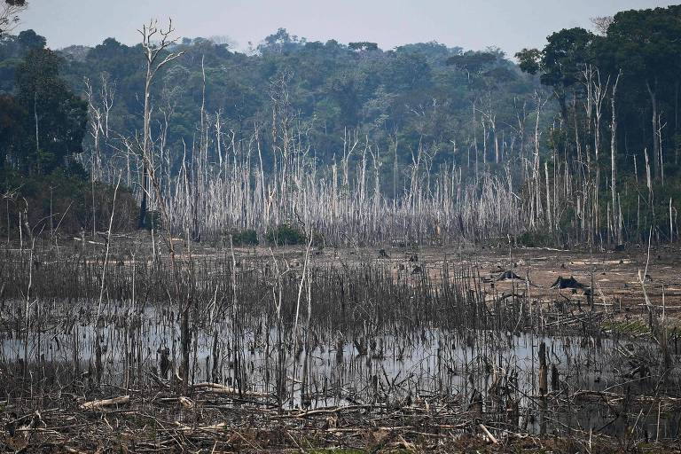
The roads opened by the dictatorship in the Amazon paved the way for a disorderly occupation of the territory by people from other regions of the country, marked by precarious land regularization, land grabbing, and illegal deforestation.
This impulse remains strong. A recent survey by the Federal Public Ministry shows that 9 of the ten areas of the Amazon with the highest incidence of deforestation in 2019 are in the sphere of influence of highways built during the military regime.
The list includes municipalities on the edge of the Transamazônica, such as Anapu (PA) and Apuí (AM); São Félix do Xingu (PA), under the influence of PA-279; areas of Rondônia, Acre and Amazonas close to BR-364; and Novo Progresso (PA), a city that emerged with the construction of BR-163.
From an economic point of view, the colonization process driven by the dictatorship has been uneven across the Legal Amazon regions. On the one hand, soy has generated wealth in some areas, mainly in cities in the north of Mato Grosso, such as Sinop, on the banks of the BR-163.
But most of the felled forest has even given way to low productivity livestock. According to a survey by the TerraClass project, a partnership between the National Institute for Special Research and Embrapa, the Legal Amazon had 12 million hectares of degraded pasture, comparable to the size of three states in Rio de Janeiro. The calculation was made in 2014.
According to ecologist Philip Fearnside, from Inpa (National Institute for Research in the Amazon), the construction of Amazon roads had more political than economic calculations.
"In the case of Transamazônica, it was ten days between Médici's visit to the victims [of the drought] and the road's announcement. There was no time for any kind of analysis or anything", he says.
"BR-319 [Manaus-Porto Velho] had no economic reasoning. It was all paranoia that the Amazon would be overtaken by international greed."
Along the Transamazônica, where thousands of colonists disposed of the plots in the first years, underutilized or abandoned pastures are a limitless sight.
Urban centers survive from federal transfers and illegal activities, mainly mining, logging, and land grabbing of public lands.
One of them, Itaituba (PA), became the center of illegal gold mining in Brazil. This position once belonged to Serra Pelada, which, in the late 1970s and throughout the 1980s, became the largest open-pit mine in the world.
In both places, wealth has generated environmental liabilities, such as contamination by mercury, without significant socio-economic benefits.
Curionópolis (PA), the municipality where Serra Pelada is located, appears in 3,378th place in the ranking of the Atlas of Human Development, while Itaituba is in 3,291th, in a list with 5,565 municipalities.
All 15 worst municipalities in the ranking, a partnership between UNDP (United Nations Development Program) and Ipea (Institute of Applied Economic Research), are in the Legal Amazon.
With such low human development, it is not surprising that the economic importance of the Amazon is poor.
Half a century after the PIN was launched, the region represents 8.7% of 2017 GDP, the most recent year available. In comparison, the city-region of São Paulo accounts for 24.6% of the Brazilian GDP.