Latest Photo Galleries


Brazilian Markets
17h31 Bovespa |
+1,09% | 128.509 |
16h43 Gold |
0,00% | 117 |
17h00 Dollar |
-0,83% | 5,0697 |
16h30 Euro |
+0,49% | 2,65250 |
ADVERTISING
Northeastern Brazil: Cliff Route Paves the Way to the Meeting Point of the Dry Lands with the Sea
12/11/2014 - 08h58
Advertising
ROBERTO DE OLIVEIRA
SPECIAL ENVOY TO CEARÁ
Between the white sand and the green depths of the sea a scenery unveils a myriad of shades: yellow, burgundy, orange, terracota, icy grey and red.
"I was in Ceará, the land of Irapuã, the land of Iracema and Tupã", as the lyrics go in the song "Aquarela Brasileira" (Brazilian Watercolor), written by a popular troubadour and recorded by samba musician Martinho da Vila.
The painting-like landscape runs through a generous scattering of cliffs on the east coast of the state of Ceará, in Northeastern Brazil.
In addition to the color palette there are marbled formations, some of them surrounded by dunes that roll out far from view.
Other cliffs are molded by thorny vegetation that turns green during the wet season. Mandacarus are everywhere, at times meddling in the rocky ground, at other times standing on the beach.
Facing the sea, close to the river current or surrounding villages, the cliffs show off their magnitude throughout the whole route.
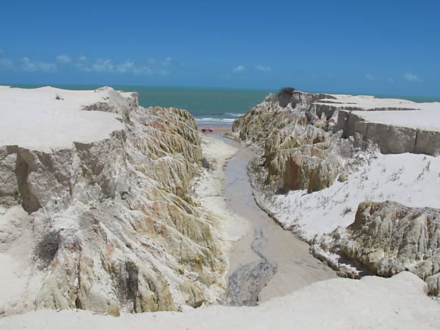
Sculpted by the unceasing power of the wind and by the to and fro of the tide, these tall cliffs, at the mercy of erosion, dominate the Cliff Route.
The path begins in the metropolitan region of the city of Fortaleza and follows through towards the boundary with the state of Rio Grande do Norte, going through eight municipalities in total along the way.
It is necessary to drive along the CE-400 motorway, called the Rising Sun Route, which connects Fortaleza to Aracati, to visit Icapuí, the home of the two most isolated beaches of the Cliff Route, Redonda and Ponta Grossa.
The sun shines almost the whole year round and the climate is hot and semihumid, with an average temperature of 27 °C.
Usually, part of the destinations that compose this route like the beaches of Águas Belas, Morro Branco and Canoa Quebrada are explored in a "day use" system.
According to the local tourism association, eight in ten tourists use this system, which works in the following way: they leave Fortaleza or the Beach Park in the tourist resort at Porto das Dunas, in Aquiraz and arrive in the desired destination the next morning.
After swimming in the sea, they go on a buggy trip and then have lunch, before returning to "base camp" at the end of the day where they upload their "selfies" and hasty photos and leave wanting more.
This route is almost 200km long and crisscrosses through beaches, dunes, mangroves, coconut trees and carnauba trees.
You can even spot the shiny kites hanging over the sea while kitesurfers ride the waves. These views deserve more than a day trip timed by tour guides.
If you are not in a hurry it is possible to explore the rustic places, talk to the fishermen and dive into the native life, or lie down on the deserted sandy beaches and bathe in the mouth of the local rivers.
There are no road tolls, but cows, donkeys, goats and lizards can cross the motorway at any given time, indifferent to the anxiety of those who want to reach their destination fast.
You can relax even your foot on the accelerator pedal and take in the views of the meeting of the dry lands with the sea.
Make room in your luggage for discoveries that are so welcomed when you are on the road.
Translated by CRISTIANE COSTA LIMA